|


 |  |

| Biologie | Botanica | Chimie | Didactica | Fizica | Geografie |
| Gradinita | Literatura | Matematica |
Chimie
|
|
Qdidactic » didactica & scoala » chimie The Mental Map of Neighborhoods in Bucharest - introductive Study of Mental Geography |
The Mental Map of Neighborhoods in Bucharest - introductive Study of Mental Geography
The Mental Map of Neighborhoods in Bucharest - Introductive Study of Mental Geography
Keywords: mental map, mental geography, urban perception, neighborhood, Bucharest
Abstract: Mental geography appears where human geography meets psychology and studies the perception of space in all its forms. The most common method of analyzing space perception is the mental map, which is an advanced cartographical research technique with a dynamic character. This paper is just an introductive study, a part of a larger research, which concentrates on neighborhoods in Bucharest. Although neighborhoods are not officially set and they are not used in administration, they are the most often used spatial references. Being unofficial, the limits, names, and even existence of most of the neighborhoods are disputed. Each citizen has their own mental map therefore this issue is perfect for a case study of mental geography.
1. Introduction and methodology
Mental geography appeared as a preoccupation for human geographers in the second half of the XXth Century (Lynch, 1960; Downs, 1970) although some ideas that human perception of space is the key for explaining some geographic phenomena can be found in Kant`s work[1].
In brief mental geography studies spatial perception. The two notions put together show very clearly the interaction between the two sciences perception is a psychological notion while space belongs to geography. An extended definition is as follows:
Mental geography is the field of interaction between geography and psychology which studies the geographical (spatial) distribution of human mental perception (after Putra, S., Yang, P, 2006).
From our point of view this definition focuses on only one part of the relation between people and space in terms of perception. It is indeed important how people's perception of space appears, develops and influences other phenomena, but we argue the way in which people get involved in the characteristics of space is equally important. People sometimes change several space features in order to change the perception they (or other people) have when they interact with that space. For example the change of street names in post-communist Bucharest. The authorities didn`t want the space to bare the signs of communism any more (The Victory of Socialism Avenue etc.), furthermore they wanted to send an anticommunism message if possible. As a result a large number of street names of anticommunist heroes appeared. Sometimes the frenzy of name changing led to problems such as two streets with the same name (for example Ion Mihalache, very important politician killed in the communist prisons). From our perspective this intervention meant to change space characteristics and so people`s perception is also a part of mental geography.
Psychology is a probabilistic science and studies the mental system. We find perception, along with sensation and representation within the subsystem of sensorial cognition processes. Humans use this subsystem to relate to the environment. This last notion of environment is largely similar in geography with space; therefore people use perception to gain knowledge about space. Perception is a personal, subjective and relative process; as a result mental geography also becomes a probabilistic science as psychology is.
Mental geography analyzes the perception of each individual and gathers a sum of different perceptions. The difference between social and mental geography is that the latter studies not the group but the individual.
The domain of mental geography is very dynamic and up-to-date. It can be used not only for scientific purposes but also with immediate utility, for example studies on inhabitants' satisfaction and residential perception as basis for marketing strategies in real estates.
The neighborhoods are the most common space references in Bucharest. From strictly spatial identification to people`s identity, these notions are frequently used in daily speech. The name of a neighborhood is used as a part of an address both in private and in real estate or commercial market, often along with a firm`s name, a store, a branch etc. (Carrefour Militari, Baneasa, Colentina; Cora Pantelimon).
At the political and administrative level the otherwise well known and used neighborhoods do not exist. The municipality of Bucharest is divided in 6 sectors. The separation of the sectors further along in neighborhoods, although it has been proposed and in one period taken into account, exists only in the inhabitants` image of the city, in their perception of urban space. In consequence this study belongs to mental geography.
Like any collective mental element, the neighborhoods know many variations at the level of each individual`s perception. Some of them are mistaken, denied, assimilated, divided or even assembled in a hierarchy (larger neighborhoods comprising smaller ones). Obviously these differences of perception appear as a result of definition differences. Each inhabitant understands in his own way this notion. This study tries to capture a general opinion, a synthesis of neighborhood images in the inhabitants` minds.
A whole new set of problems is brought into discussion by the place of residence of the interviewed people. A citizen has a clear image of his place of living and the nearest one, but this image can suffer deformation if it refers to further away places, which he may have visited rarely or even never seen them. In the second case we deal with an external generated perception (secondary) induced by general opinion, stereotypes or mass media. To reduce to minimum the negative influences of this problem regarding the study, two different stages of analysis have been designed. Stage A captures the opinions of the inhabitants on neighborhoods in the whole city (thus probably mostly external generated) while stage B analysis the perception on the place of residence and on the surrounding ones.
The purpose of the study is to create a mental map after each stage. The qualitative aspects of the neighborhoods are not a priority. The differences observed after comparing the two maps will show in what way the opinions of the inhabitants concerning their own place of residence differ from the general opinion.
The research is obviously inductive and it can be considered positivist as it analyzes social processes and operates with representations. As a difference from the classic model this research has a dominant quantitative quality and mostly uses the survey technique (Finn, M., Elliott-White, M., Walton, M., 2000). The steps of the research are as follows:
a. Identification of potential neighborhoods. Using several works on the history of Bucharest and an internet search engine we created a list of names which appear as neighborhoods from at least 3 sources.
b. The level in which each neighborhood is recognized. The list of potential neighborhoods has been included in a questionnaire. The respondents were asked to mark the names they consider as being neighborhoods of Bucharest. The sample has been chosen following the recommendations of Finn and al. (2000). We used the method of stratified sampling (Toyne and Newby, 1990), considering equal representation of age, gender and sector residence (Table 1).
|
Age |
15 - 30 |
31 - 50 |
over 50 |
Total |
|||
|
Gender |
M |
F |
M |
F |
M |
F |
|
|
Sector 1 |
5 |
5 |
5 |
5 |
5 |
5 |
30 |
|
Sector 2 |
5 |
5 |
5 |
5 |
5 |
5 |
30 |
|
Sector 3 |
5 |
5 |
5 |
5 |
5 |
5 |
30 |
|
Sector 4 |
5 |
5 |
5 |
5 |
5 |
5 |
30 |
|
Sector 5 |
5 |
5 |
5 |
5 |
5 |
5 |
30 |
|
Sector 6 |
5 |
5 |
5 |
5 |
5 |
5 |
30 |
|
Total |
30 |
30 |
30 |
30 |
30 |
30 |
180 |
Table 1 Stratified sampling for the potential neighborhoods survey
The total sample resulted is 180 respondents. The results have been interpreted using elementary statistical operations (average, percents) and a list of 25 neighborhoods recognized by over 51% of the respondents has been created.
c. Placing the cores of recognized neighborhoods - The mental map of neighborhoods from the general point of view (MMNG). In all cases the name of the neighborhood can be spatially identified as an official street name, a communication node, a landmark etc, this spatial element has been considered the core of the neighborhood. For example for Pantelimon neighborhood the official spatial core is the Pantelimon Road.
The result is a map of Bucharest with 25 neighborhood cores. It is presumed that the core name extends on the surrounding residential areas until it reaches a certain edge (Carter, 1990). The result is a dynamic map (using GIS) with three elements: the cores and their extents, the disputed areas (where two or more neighborhoods overlap) and unclaimed areas (where none of the 25 neighborhoods exist). This is the MMNG.
d. Conclusions
|
2. Clarifying the concepts
The mental map transposes images in a spatial context (Carter, 1990). It is defined by relativity, flexibility and subjectivity. Relativity means that a mental map can never be absolute. The image of space differs from one individual to another, so an identical impression of several individuals is almost impossible to find. Flexibility can be found in space or in time. In space the mental map can suffer modifications according to the group that expresses its perceptions. For example the inhabitants with the age of 15 to 30 years have different opinions from the over 50 group, and so the map suffers spatial modifications. Also inhabitants have a less clear image about a faraway place compared to the case of their own place of residence or activity. In time the mental map can change along with the change of perception. The inhabitants living very close to a neighborhood considered nowadays as "good" have the tendency to identify themselves with that area although previously they had a different opinion. The rule is also reversible: the inhabitants living close to "bad" neighborhoods identify themselves with surrounding areas or they create their own new neighborhood in order to emphasis the difference between their space and the "bad" space. The evolution of some landmarks in urban landscape can also change the mental map. The development of communication nodes, subway stations for example, can determine some change of neighborhood names or even form new neighborhoods. As a result the southern part of the Berceni neighborhood becomes Aparatorii Patriei (the name of the subway station), and Pieptanari becomes in a very short time Eroii Revolutiei (after changing the name of the subway station to honor the Heroes of the 1989 Revolution).
The subjectivity is obvious and appears following the difference of definition. Each individual has their own definition for the term "neighborhood". The most common are "area with the same characteristics", "residential area", "area close to an important urban path", "area built in the same period" and even "a community".
In conclusion the mental map captures the general opinion on space in a certain moment.
Lynch (1960) proposed five elements through which urban space is perceived:
Paths used by people to move within the city;
Edges or linear elements which mark discontinuities, obstacles in the urban landscape;
Nodes or points of convergence inside the city;
Landmarks or important points in the urban landscape;
Districts (neighborhoods) "sections of the city immediately identifiable by the inhabitants and having local names".
The neighborhood is an insufficiently studied and explained element of urban space. The studies of urban geography refer to functional areas and other elements of urban planning and the direct opinion of the inhabitants is neglected (Carter, 1990). The citizens have their own functional areas which are subjective, relative and mobile. To form a definition we considered the essential characteristics of the term: a residential area, unitary and organic, easily identified by the inhabitants and having a local name.
3. Stage A
The list of potential neighborhoods identified from at least three sources is as follows:
- 13 Septembrie
- 23 August
- Andronache
- Aparatorii Patriei
- Aviatorilor
- Aviatiei
- Baicului
- Balta Alba
- Baneasa
- Berceni
- Bucurestii Noi
- Brancoveanu
- Brancusi
- Centrul Civic
- Centrul Istoric
- Chitila
- Colentina
- Cotroceni
- Crangasi
- Damaroaia
- Dealul Spirii
- Delfinului
- Domenii
- Dorobanti
- Dristor
- Drumul Taberei
- Dudesti
- Ferentari
- Floreasca
- Francez
- Gara de Nord
- Ghencea
- Giulesti
- Grivita
- Grozavesti
- Henri Coanda
- Iancului
- Industriilor
- Ion Mihalache (1 Mai)
- Militari
- Mosilor
- Muncii
- Nicolae Tonitza
- Obor
- Oltenitei
- Pajura
- Pantelimon
- Pipera
- Piata Romana
- Primaverii
- Rahova
- Resita
- Salajan
- Sebastian
- Sfanta Vineri
- Straulesti
- Stefan cel Mare
- Tei
- Tineretului
- Titan
- Unirii
- Vatra Luminoasa
- Vacaresti
- Vitan
- Voluntari
The list contains names of villages from the surrounding areas (Voluntari, Chitila), or areas which don`t exist anymore (Dealul Spirii, a whole hill which was practically moved in the process of building the Palace of Parliament), but all these were found in the literature and on the internet presented as nowadays neighborhoods so it cannot be neglected.
After the survey involving 180 inhabitants aged over 15 years and living in Bucharest for more than 5 years we obtained the following results (Table 2):
|
Rank |
Name |
No. of recognitions |
|
|
1 |
Berceni |
171 |
95 |
|
2 |
Pantelimon |
171 |
95 |
|
3 |
Rahova |
171 |
95 |
|
4 |
Ferentari |
166 |
92 |
|
5 |
Crangasi |
162 |
90 |
|
6 |
Militari |
162 |
90 |
|
7 |
Colentina |
160 |
89 |
|
8 |
Drumul Taberei |
160 |
89 |
|
9 |
Bucurestii Noi |
148 |
82 |
|
10 |
Floreasca |
144 |
80 |
|
11 |
Baneasa |
142 |
79 |
|
12 |
Titan |
142 |
79 |
|
13 |
Giulesti |
139 |
77 |
|
14 |
Primaverii |
139 |
77 |
|
15 |
Vitan |
135 |
75 |
|
16 |
Balta Alba |
133 |
74 |
|
17 |
Ghencea |
121 |
67 |
|
18 |
Pipera |
121 |
67 |
|
19 |
Cotroceni |
115 |
64 |
|
20 |
Tei |
112 |
62 |
|
21 |
Damaroaia |
110 |
61 |
|
22 |
Dristor |
110 |
61 |
|
23 |
Tineretului |
103 |
57 |
|
24 |
23.aug |
101 |
56 |
|
25 |
Salajan |
92 |
51 |
|
26 |
Dorobanti |
88 |
49 |
|
27 |
Pajura |
88 |
49 |
|
28 |
Obor |
83 |
46 |
|
29 |
Aviatorilor |
79 |
44 |
|
30 |
Aviatiei |
79 |
44 |
|
31 |
13.sep |
74 |
41 |
|
32 |
Voluntari |
74 |
41 |
|
33 |
Grivita |
70 |
39 |
|
34 |
Ion Mihalache (1 Mai) |
68 |
38 |
|
35 |
Vatra Luminoasa |
65 |
36 |
|
36 |
Aparatorii Patriei |
61 |
34 |
|
37 |
Francez |
61 |
34 |
|
38 |
Dudesti |
59 |
33 |
|
39 |
Grozavesti |
59 |
33 |
|
40 |
Baicului |
56 |
31 |
|
41 |
Andronache |
54 |
30 |
|
42 |
Vacaresti |
54 |
30 |
|
43 |
Brancoveanu |
47 |
26 |
|
44 |
Iancului |
47 |
26 |
|
45 |
Mosilor |
47 |
26 |
|
46 |
Gara de Nord |
45 |
25 |
|
47 |
Muncii |
45 |
25 |
|
48 |
Stefan cel Mare |
45 |
25 |
|
49 |
Centrul Civic |
41 |
23 |
|
50 |
Unirii |
38 |
21 |
|
51 |
Henri Coanda |
36 |
20 |
|
52 |
Oltenitei |
36 |
20 |
|
53 |
Centrul Istoric |
32 |
18 |
|
54 |
Domenii |
32 |
18 |
|
55 |
Dealul Spirii |
27 |
15 |
|
56 |
Industriilor |
23 |
13 |
|
57 |
Piata Romana |
23 |
13 |
|
58 |
Brancusi |
20 |
11 |
|
59 |
Sebastian |
20 |
11 |
|
60 |
Resita |
18 |
10 |
|
61 |
Sfanta Vineri |
14 |
8 |
|
62 |
Nicolae Tonitza |
13 |
7 |
|
63 |
Straulesti |
13 |
7 |
|
64 |
Delfinului |
9 |
5 |
|
65 |
Chitila |
5 |
3 |
Table 2. The results of the survey
4. Conclusions
It can be observed that 25 neighborhoods were recognized by the majority of the respondents. It is interesting that none of the neighborhoods have been unanimously recognized and also that there are no neighborhoods that haven't been recognized at all. (Table 1 and Figure 1)
Regarding the gender repartition (Figures 2 and 3) a certain uniformity of the opinions can be observed. Still the differences appear in the cases of the new neighborhoods (Nicolae Tonitza, Constantin Brancusi and Henri Coanda) which were recognized more by men. For example, the Nicolae Tonitza neighborhood wasn't recognized by any women, Brancusi was recognized by few women and Henri Coanda, which has been in the attention of the media, had a balanced proportion. Also less known neighborhoods like Andronache or Straulesti had been identified more often by men. The conclusion could be that the men are better informed. Also a tendency was registered, that of men recognizing many neighborhoods from the list and so they are first in the top of the neighborhood gender recognition chart.
For the age groups the situation isn't as homogenous as in the case of the gender groups. (Figures 4 and 5). A strong variation can be remarked mostly in the over 50 years age group. This is the group that recognized many names as being neighborhoods. This can be explained by the fact that the persons over 50 have lived in Bucharest for more time know it better and in different historical periods, so they have heard of more neighborhoods. Another observation is that a great part of the people between 31 and 50 years old recognized important neighborhoods. Also it must be said that the level of recognition of this particular group for the elements that have the smallest percentage of recognition in other groups is under the level of the other groups. An essential element is the recognition of communication node neighborhoods (Dristor) and of those intensely promoted by the media (Pantelimon, Salajan), especially by the first age group.
Stage B of this research is presently undergoing. The official sources in which neighborhoods are present (subway maps and route directions) will also be discussed in this second phase.
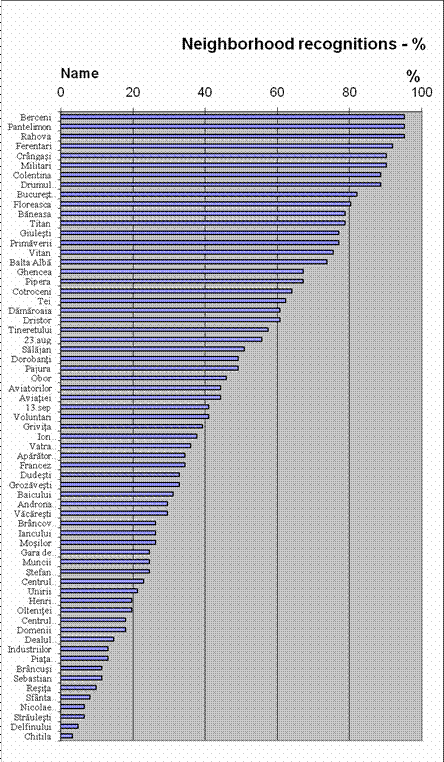
Figure 1
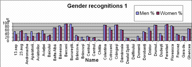
Figure 2
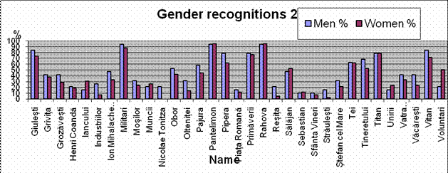
Figure 3
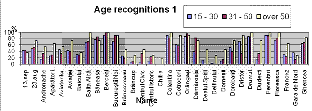
Figure 4
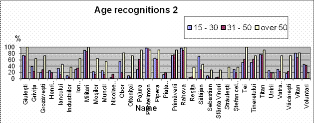
Figure 5
Selective references
Batty M, (2001), Exploring isovist fields: space and shape in architectural and urban morphology, Environment and Planning B: Planning and Design, in Putra, S., Yang, P, (2006)
Carter, H., (1990), The Study of Urban Geography, Edward Arnold, London
Downs, R. M., (1970), Geography Space Perceptions: past approaches and future prospects in Progress in Geography 2; in Carter, H., 1990, The Study of Urban Geography, Edward Arnold, London
Finn, M., Elliott-White, M., Walton, M., (2000), Tourism and Leisure Research Methods, Pearson Education, Harlow, Essex
Hillier, B., Hanson, J. (1984), The Social Logic of Space. Cambridge University Press , in Putra, S., Yang, P, (2006) Analyzing Mental Geography of Residential Environment in Singapore using GIS-based 3D Visibility Analysis, Conference "Doing, thinking, feeling home" - 14/15 October - Delft, The Netherlands
Llobera, M. (2003). Extending GIS-based visual analysis: the concept of visualscapes. International Journal of Geographical Information System. vol. 17 no. 1, in Putra, S., Yang, P, (2006)
Lynch, K., (1960), The Image of the City, Cambridge, Mass.; in Carter, H., 1990, The Study of Urban Geography, Edward Arnold, Londra
Matei, S. A., Ball-Rokeach, S. J., Qiu, J. (2001), Fear and Misperception of Los Angeles Urban Space. A Spatial-Statistical Study of Communication-Shaped Mental Maps, Communication Research, Vol. 28 No. 4, August 2001 429-463, Sage Publications
Putra, S., Yang, P, 2006, Analyzing Mental Geography of Residential Environment in Singapore using GIS-based 3D Visibility Analysis, Conference "Doing, thinking, feeling home" - 14/15 October - Delft, The Netherlands
[1] Kant,
| Contact |- ia legatura cu noi -| | |
| Adauga document |- pune-ti documente online -| | |
| Termeni & conditii de utilizare |- politica de cookies si de confidentialitate -| | |
| Copyright © |- 2025 - Toate drepturile rezervate -| |
|
|
|||
|
|||
Referate pe aceeasi tema | |||
|
| |||
|
|||
|
|
|||