|


 |  |

| Afaceri | Agricultura | Comunicare | Constructii | Contabilitate | Contracte |
| Economie | Finante | Management | Marketing | Transporturi |
Constructii
|
|
Qdidactic » bani & cariera » constructii The survey instruments and methods of geometric level |
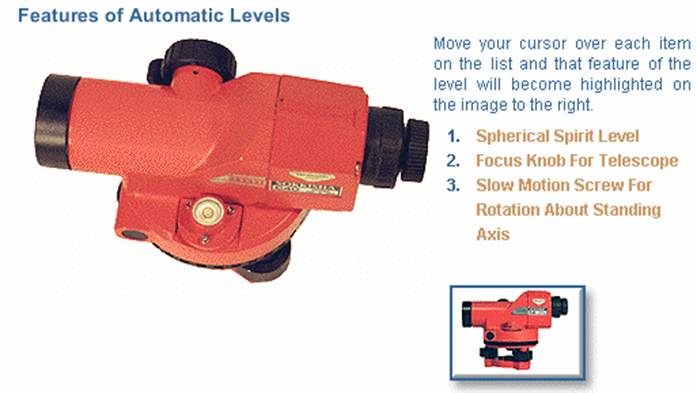
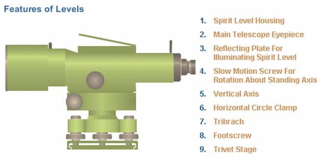
The survey instruments and methods of geometric level
The survey instruments and methods of geometric level
Rod construction and materials
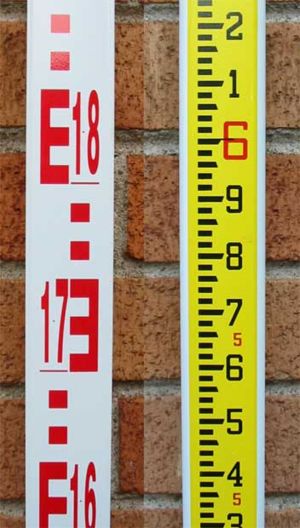
Two sides of a modern surveyor's leveling rod.
Metric graduations on the left, imperial on the right.
Levelling rods can be one piece, but many are sectional and can be shortened for storage and transport or lengthened for use. Aluminum rods may adjust length by telescoping sections inside each other, while wooden rod sections are attached to each other with sliding connections or slip joints.
There are many types of rods, with names that identify the form of the graduations and other characteristics. Markings can be in imperial or metric units. Some rods are graduated on only one side while others are marked on both sides. If marked on both sides, the markings can be identical or, in some cases, can have imperial units on one side and metric on the other.
Reading a rod
In the photograph on the right, both a metric (left) and imperial (right) leveling rods are seen. This is a two-sided aluminum rod, coated white with markings in contrasting colors. The imperial side has a bright yellow background.
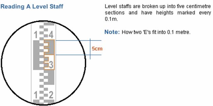
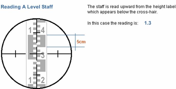
The metric rod has major numbered graduations in meters and tenths of meters (e.g. 18 is 1.8 m - there is a tiny decimal point between the numbers). Between the major marks are either a pattern of squares and spaces in different colors or an E shape (or its mirror image) with horizontal components and spaces between of equal size. In both parts of the pattern, the squares, lines or spaces are precisely one centimeter high. When viewed through an instrument's telescope, the observer can easily visually interpolate a 1 cm mark to a quarter of its height, yielding a reading with accuracy of 2.5 mm. On this side of the rod, the colours of the markings alternate between red and black with each meter of length.
The imperial graduations are in feet (large red numbers), tenths of a foot (small black numbers) and hundredths of a foot (unnumbered marks or spaces between the marks). The tenths of a foot point is indicated by the top of the long mark with the upward sloped end. The point halfway between tenths of a foot marks is indicated by the bottom of a medium length black mark with a downward sloped end. Each mark or space is approximately 3mm, yielding roughly the same accuracy as the metric rod.
Classes of rods
Rods come in two classes:
1. Self-reading rods (sometimes called speaking rods).
2. Target rods.
Self-reading rods are rods that are read by the person viewing the rod through the telescope of the instrument. The gradations are sufficiently clear to read with good accuracy. Target rods, on the other hand, are equipped with a target. The target is a round or oval plate marked in quarters in contrasting colours such as red and white in opposite quarters. A hole in the centre allows allows the instrument user to see the rod's scale. The target is adjusted by the rodman according to the instructions from the instrument man. When the target is set to align with the crosshairs of the instrument, the rodman records the level value. The target may have a vernier to allow fractional increments of the graduation to be read.
Topographer's rods
Topographer's rods are special purpose rods used to ease conducting topographical surveys. The rod has the zero mark at mid-height and the graduations increase in both directions away from the mid-height.
In use, the rod is adjusted so that the zero point is level with the instrument (or the surveyor's eye if he is using a hand level for low-resolution work). When placed at any point where the level is to be read, the value seen is the height above or below the viewer's position.
|
An alternative topographer's rod has the graduations numbered upwards from the base
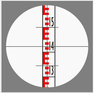
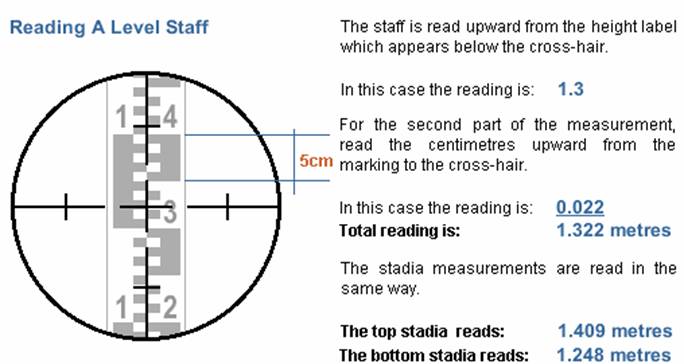
Surveyor's view of the leveling rod with the crosshair. This indicates a reading of 1.422 m
Stadia rods
A normal leveling rod can be used for stadia measures at shorter distances (up to about 125 m). For longer distances, special stadia rods are better suited. In order to provide good visibility at long distances, stadia rods are typically wider than leveling rods with larger markings. Since very fine gradations are not necessary for long sights, they may be left off the dedicated stadia rod.
Usage
A typical surveyor's instrument reticle has two pairs of stadia marks. One pair is on the horizontal centerline and the other on the vertical. Each functions in the same manner and are placed for measuring on either axis.
The stadia marks are set a specific distance apart. The distance is chosen so that there is a fixed, integer ratio between the distance observed between the marks and the distance from the telescope to the measuring device observed. This is known as the stadia constant or stadia interval factor. For example, typical stadia mark pair are set so that the ratio is 100. If one observes a stadia rod, rule or leveling rod with the telescope and sees that the rod spans 0.5m between the marks (the stadia interval), then the distance from the instrument to the rod is:
0.5m x 100 = 50 m.
In the image to the right, the upper stadia mark is at 1.5 m and the lower at 1.345 m. The difference is 0.155 m. Thus the distance from the instrument to the leveling rod is:
0.155 X 100 = 15.5 m.
Levels
Levels can be used for:
Determining the height of a particular point
Determining differences in height between points
Determining the contours of a land profile
Providing data for road cross-sections
Providing data to calculate volumes for earthworks
Setting out level surfaces for construction
Setting out inclined surfaces for construction
Factors Which Influence the Use of Levels
Clear lines of sight needed between known and unknown points. There is no need to physically travel between the target and reference points.
Height precision is dependent upon the precision of instrument used and the length of the line of sight.
Height accuracy is maintained through proper adjustment of the level and correct field procedures.
Survey Methods Used For
Levels determine differences in height between two or more points.
Models
To determine the difference in height between different points it is necessary to produce a line of sight. This requires the use of an instrument. In surveying, this instrument is known as a surveyor's level, often generically known as a dumpy level although, as we will see, this is not strictly correct. All of levels consist of a telescope with a cross hair or gun sight, mounted on a device that enables us to orient the device in a horizontal plane.
There are three types of levels:
dumpy levels, tilting levels ,automatic levels ; the differences between the three types being in the way in which the instruments are designed to be adjusted to give a horizontal line.
Precision
The three types of levels can be further divided into different classes defined by their precision.
Precise
Very accurate instruments for geodetic or any other very precise leveling. It should be possible to level such an instrument to within +0.2'.
Details of Level Construction
Parallel-Plate Micrometer for Precise Levels
In general, the line of sight will intersect a leveling staff between two graduations. The value must be interpolated between the graduations if readings of this accuracy are required. If a parallel sided glass block is placed in front of the objective lens and rotated about a horizontal axis and perpendicular to the line of sight, the distance between a graduation and the line of sight may be measured
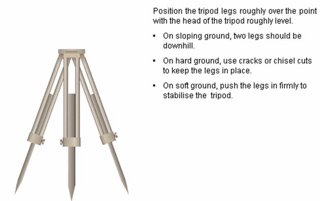
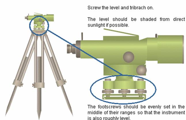
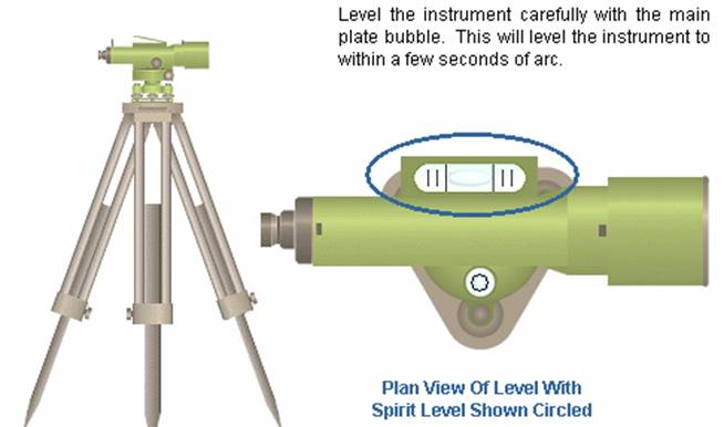
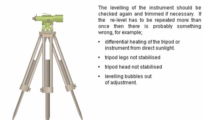
Setting up a Level
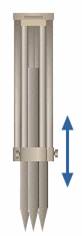
Levelling Staff
Precision of Leveling
The precision of the height measurement made by a level is directly related to the precision of the leveling bubble through propagation of error. The error in height subtended by a small error in the angle at the level is linked through the distance from the instrument to the staff:
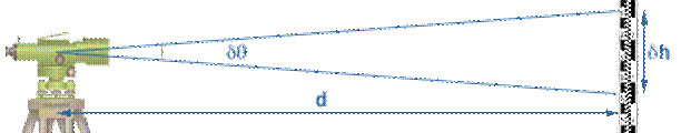
From the rule for the length of a circular arc:
h = d
For a precise level is smaller because the level bubble is more sensitive. Therefore the precision of the height reading on the staff is better than that of a standard tilting or automatic level
|
|
2 |
|
| Contact |- ia legatura cu noi -| | |
| Adauga document |- pune-ti documente online -| | |
| Termeni & conditii de utilizare |- politica de cookies si de confidentialitate -| | |
| Copyright © |- 2025 - Toate drepturile rezervate -| |
|
|
|||||||
|
|||||||
|
|||||||
Lucrari pe aceeasi tema | |||||||
|
| |||||||
|
|||||||
|
|
|||||||